Edit on March 6, 2026
This morning I find on Facebook this post from Rian Nelson which I find of great interest.
“I was standing by the temple talking to Brother Woodruff and he pointed out a spot to me on the opposit[e] side of the river about a mile and a half above Montrose, and said there would be a city and a temple built there and the place would be called Zarahemla. I was at Nauvoo when the temple was finished and dedicated. I went up into the tower and wrote my name there. As I understand, the wicked have burned that temple to the ground and it is all destroyed like the Jerusalem temple. But I expect to see that temple re-erected and the one built on the opposite side of the river to match.” Autobiography of Edward Phillips
Any time I talk about the location of Zarahemla, I usually begin with Doctrine and Covenant section 125:3.
3 Let them build up a city unto my name upon the land opposite the city of Nauvoo, and let the name of Zarahemla be named upon it.
Now keep this in mind. The Lord does not specifically state that this is Zarahemla. It may be a strong hint as I think it is.
In this write up, I will go over parallels of this land opposite the city of Nauvoo and make a determination as to whether or not there are evidences for and against the claim that this is actually the location of the ancient city of Zarahemla.
I did make a video a few years ago. I do get embarrassed every time I watch the video as I spelled the name Zarahemla wrong on the maps. Nevertheless the main concepts of the video are still valid. Basically I deconstruct the geography of the land based on the descriptions given in Alma 2 which covers the battle with Amlici.
From the Battle with Amlici, we learn the following features.
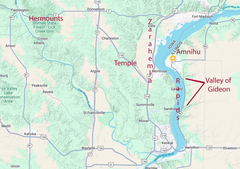
- Zarahemla is on the west of the river Sidon.
- Hill Amnihu is on the east of the river Sidon.
- Minon is higher elevation than Zarahemla.
- Minon is on the west of the river Sidon.
- Minon is south of Zarahemla (course of the land of Nephi).
- Since Minon is south of Zarahemla, the valley of Gideon would also be south of the Hill Amnihu and Zarahemla.
- On foot river crossing. A portion of the battle took place in the water near Minon and the Valley of Gideon.
- Direction of flight after the battle was west and north.
- Hermounts would be north westerly of Minon.
- Hermounts would have burial mounds.
- Hermounts would have beasts and vultures.
- Zarahemla should also have an ancient wall (we learn this in the Book of Helaman).

Zarahemla Temple Lot
In Montrose IA, There is a plot of land directly to the other side of the Mississippi River facing the Nauvoo Temple which has been isolated by some proponents to be the Zarahamla Temple Lot. The proponents may be correct. But it is difficult to conclude with any certainty that they are correct. You have a plot of land that was never plowed, surrounded by a small berm. There is a large man-made pit of sand underground that is about the size and dimensions of a Hebrew temple. The pit of sand has vertical walls of earth on each side and it is more than ten feet deep. There is a quote from Joseph Smith proclaiming that there will some day be sister temples on both sides of the Mississippi River directly in the area. There are lunar alignments after the manner of the Hebrews that match directly to the Nauvoo Temple as well as with a marker on the proposed Hill Amnihu. And finally, on that plot of land was found the highly medicinal Spotted Bee Balm plant. From my time being involved with the research on that land, that was pretty much it. Magnetometry and Electro Resistivity studies where done on the land. Interesting and consistent features may have existed on that land anciently which are consistent with it potentially having been the ancient Zarahemla temple site. But by no means have any studies been able to conclusively tell anyone that it is definitely where King Benjamin once delivered his powerful sermon as he handed over the kingship to his son Mosiah. Personally, I put it down as a maybe.


Hill Amnihu
The owners of the proposed Hill Amnihu have taken the stewardship over the land very seriously and seek preservation. They really do not like much information about it to be pushed out publicly. I have been on the land. But just like everything else in Book of Mormon Geography, I and others think it is the location of Amnihu. We cannot prove it. We do not really want to prove it. The land does currently have an official designation of an ancient graveyard due to the large number of scattered burial mounds found on it.
In the video, I stated that the hill was a native-american mound. I no longer believe that to be the case. It is a natural hill.
Valley of Gideon and the River Crossing
The river crossing in the battle with Amlica would be part of the Des Moines Rapids. A survey of the Des Moines Rapids was published in 1837 which demonstrated potential areas for a foot crossing. The dark areas of the river represent shallow areas.
The image I have provided here is inadequate. You need to see the high resolution image to see the actual depths recorded in the survey. To do so, go to the following website and zoom in on the image.

What is significant about the Des Moines rapids is that the water was too shallow for boat travel and the bottom was made of hard limestone. This created a problem for boat navigation which was eventually fixed by the building of levies which raised the water levels sufficiently to solve the problem needed for boat travels.
The Valley of Gideon
The location of the Valley of Gideon is a future work which I will do next time I am in the area.
Minon
Minon would be the red dot on the map which is where the battle with the Lamanites took place in Alma 2 – near Sandusky. It is significantly higher in elevation compared to Zarahemla and all of the Valley of Gideon area. I will provide pictures next time I visit the area.
The Flight Path from the Battle
Alma 2:37 Yea, they were met on every hand, and slain and driven, until they were scattered on the west, and on the north, until they had reached the wilderness, which was called Hermounts; and it was that part of the wilderness which was infested by wild and ravenous beasts.
The Des Moines river created the flight path of the battle which led the soldiers to the west, and then the to north, and then to the west, and then to the North, and so forth, until they arrived at Hermounts. The Des Moines River is of significant size as you can see in the picture below.

Hermounts
The Shimek State Forest most certainly fits the geographical description of Hermounts. It has steep cliffs and is forested wilderness to this day. It is Northwesterly of the direction of where the Alma 2 battle would have taken place which matches to the descriptions given.
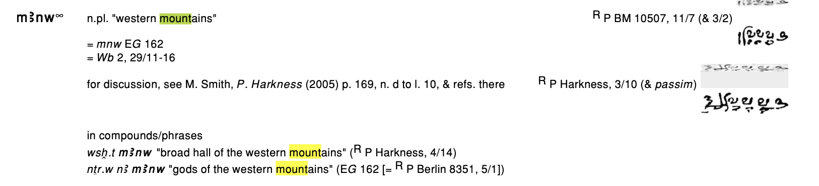
The name Hermounts does appear to have ancient Egyptian roots. HR means to be pleased, content, or at peace. While the second part is not a direct lingustic match, it is very close. MANW means western mountains. TSh is in the Demotic Dictionary meaning “boundary”. It appears that Hermounts is probably an Egyptian word meaning “the peaceful mountain boundary”.


I have not found burial mounds, beasts, and vultures in this state park, but I only spent one afternoon there. It is definitely wilderness area.
The Zarahemla Wall
The Heartland Research Group did have a Lidar survey done and they believe they have found the wall. I have not yet seen it so I am not ready to give an opinion of it. Nevertheless, here is a Flipsnak Presentation put together by Jay Mackley for you to look at.
https://www.flipsnack.com/B77FEFCC5A8/the-wall-of-zarahemla-vu90xhhgvu.html.
Images from this presentation are given below at the end of this write-up.
Question: If we analyze Alma Chapter 2, can we find strong candidates for all of the land features?
Answer: The answer is YES.
I still have more research to attend to in order to answer satisfactorily to all land points as being definitively identified as strong candidates. Nevertheless, to me, it is looking quite promising.
There is enough here for me to accept that Zarahemla is indeed the land right across from the Mississippi River (The River Sidon) from Nauvoo, Illinois. Today, we call it Montrose, Iowa. By no means do I believe that I have proven to anyone that this is unquestionably the location of the ancient Zarahemla. But there is enough to show that you cannot dismiss it.
Here is another additional interesting videos by John Lefgren relevant to church history and the land.
Screenshots of the flipsnack book are given below:


